Early Results Show Warren Hall Experiment Likely a Success
August 22, 2013

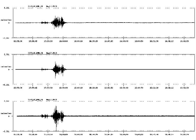
Based upon data received by a personal seismograph in the south science building connected the USGS’s existing network, the implosion of the Warren Hall structure provided enough of an impact to be captured by the seismic sensors, said Geology Professor Luther Strayer, the original creator of the experiment.
The experiment captured seismic waves released by the demolition. By observing the direction of travel and the velocity of the waves, the USGS will be able to create a 3D map of the Hayward Fault, and discover whether there are other existing faults attached to it, and the geological makeup of the soil in the surrounding areas.
Doubts were raised after J. Mark Loizeaux, president of the company charged with the demolition, told the press that any vibrations released by the implosion would be “extremely faint.”
“If you go back to that date, you can find the record…and it shows that we did get an excellent signal on the NetQuakes box on campus,” said Strayer.
Strayer was also successful in lobbying the Federal Aviation Administration to implement a no-fly zone over the campus during the demolition. Scientists were concerned that the vibrations of the news helicopter rotors pounding away above the campus would distort the data picked up the seismographs.
“I just politely ask[ed] people,” said Strayer. “I told them what I wanted, and then asked them exactly who I needed to talk to and what I needed to say to get what I wanted.”
By the time the no-fly zone was established, most local news agencies had agreed to not use helicopters to cover the event, he said. However many pushed back, worried their competitors might get the leg up on coverage of the event.
“Nobody flew. I worked with the Oakland center, and Northern California Control, and as well as the DC guys in the FAA,” said Strayer.
NetQuakes is a project started by the USGS to help precisely locate the epicenter of earthquakes and the magnitude and the fault orientation. Seismographs are bolted inside the homes and office structures of volunteers, which send data back to their network in real-time to help the processing of data.


