Warren Hall Demolition Allows Rare Opportunity to Map Hayward Fault
June 13, 2013
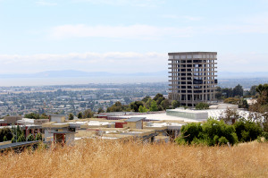
In a landmark study of the Hayward Fault, the United States Geological Survey plans to record seismic waves released by the demolition of Warren Hall in mid-August to study the fault’s structure and predict the impact of future earthquakes, the USGS reports.
The project was conceived by Luther Strayer, Ph.D., a professor of Geology at CSU East Bay. Strayer originally came up with the idea in late 2012 as he saw the demolition team begin the process of stripping down Warren Hall. As he drove under the bridge daily, between the library and the abandoned building, the idea began to develop within his mind.
“I just basically saw an opportunity,” said Strayer. “I’m not a seismologist, what I am is a structural geologist, but I recognized the awesome opportunity for the scientific community and the university.”
The experiment will give the USGS a rare chance to study the effects of a high velocity impact on the Hayward Fault. When the Warren Hall building is imploded, Strayer explained, the force of the demolition will be absorbed by the fault, located just 0.4 miles southwest of the building.
The USGS reports that the earthquake that will hit the Hayward Fault, which is overdue, is estimated to be anywhere between magnitude 6.5 and 6.8. Concerns that the demolition would trigger an earthquake on the fault were ruled out by USGS scientists.
Through the placement of seismographs in the surrounding area the USGS will measure the velocity of the waves released by the demolition as it travels through the subsurface and the rocks beneath the fault.
Leslie Gordon of the USGS explained that the experiment will allow the USGS to map the fault’s structure. The seismic waves released by the demolition will act as a type of sonar that they can use to form a 3D image of the fault.
If the waves move quickly in a certain area, Gordon explained, this will indicate that the underlying geology is solid bedrock which will be more stable during an earthquake. However if the waves released by the demolition travel more slowly, this will show that the ground in that specific area is formed of loose sediment, which is more susceptible to heavier shaking in the event of an earthquake.
“By understanding what the subsurface is made of,” said Gordon, “Where there’s rock and the different layers and the types of rocks, we can get a better idea of what will happen during the real earthquake. We can say, well, this area of Hayward might shake more violently than this other area.”
Scientist John Evans of the USGS hopes to place tilt sensors on the rubble of Warren Hall after the implosion to measure how the slabs fall after the building has collapsed. This will simulate what could potentially happen in the event of a real earthquake, where a building has collapsed and firefighters have to search through the rubble looking for survivors.
Evans could not available to comment on the project, but Gordon explained the reasoning behind the project was to give the first responders a sense of how buildings will react after an earthquake. The demolition team as of this writing, according to USGS reports, has not approved Evans’ project.
“For future earthquakes, if there are rescue crews or dogs looking for people in collapsed buildings, we want to make sure that it’s safe for first responders. We don’t want to send them into a building that’s going to collapse further,” said Gordon.
The USGS is currently in the process of searching for suitable locations to deploy the seismographs. Gordon explained that through the use of Google Maps and Google Earth, they are looking for anything from vacant lots to businesses, parks and private homes close to the fault where they can plant the devices to collect data from the implosion.
Once appropriate sites are identified they hope to recruit volunteers, primarily graduate students from local universities like UC Berkeley, CSUEB and Stanford, to engage in the physical labor of setting the seismographs in place before the implosion. Gordon estimates that there will be close to 500 seismographs used to collect the data.
The USGS is required by federal law to release the data it compiles from the demolition within the next two years. Strayer estimates that the data will be uploaded to a server and accessible to scientists almost immediately after the demolition. However the data compiled will not be readily usable for cities or other local agencies seeking to retrofit buildings identified as being located in damage prone areas.
“The processing of the data and the conclusions that come from it will take some time,” said Strayer.


